H-3 History
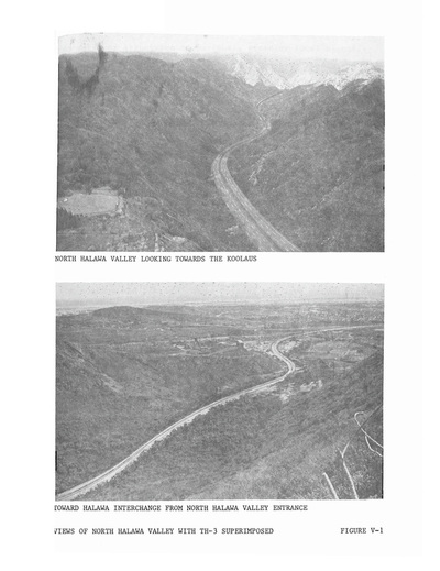
Original picture of the proposed TH-3 superimposed
The original planned H-3 was in such great disagreement that an alternative alignment was suggested named “TH-3”. The TH-3 was suggested to lower cost and plan another alignment to satisfy a survey for archeological sites in and around the proposed H-3 alignment. The TH-3’s design incorporated six lanes for both directions of traffic, while the H-3 design incorporated four lanes for both directions (Draft Supplement to the Interstate H-3 Environmental Impact Statement page 19 and 29 Picture). The estimated cost of the H-3 in 1967 was about $480,312,000, while the alternative TH-3 would cost approximately $320,430,000 (Draft Supplement to the Interstate H-3 Environmental Impact Statement Page 35 Table/chart). After much debate the H-3 alternative, four laned highway was picked over the TH-3 alternative. The H-3 was significantly higher in cost compared to the TH-3 alternative, but builders defrayed the cost of building the highway by using long spans between the viaducts which lowered the amount of pillars needed and minimized the disruption to the land below the highway (Bert, Ray, page 2 para 6) The H-3 project would be the first ever, public project in Hawaii to require an Environmental Impact Statement (Bert, Ray page 2 para 2). Most of the land in Halawa and Haiku valley were owned by the Coast Guard. When the H-3 was to be completed, it would join the Eisenhower National Defense System of Interstate Freeways. This designation means that when at war, the U.S. has jurisdiction to use the freeway to transport anything that may impact the current war, during; and only during wartime.
For more Info go to...
<http://www.interstate-guide.com/i-h-003.html>
<http://the.honoluluadvertiser.com/article/2006/Jul/26/ln/FP607260359.html>.
<http://the.honoluluadvertiser.com/article/2006/Jul/26/ln/FP607260359.html>.
